
My sisters and I have deep roots in Slope County as many of our maternal ancestors homesteaded there, including our extremely intrepid great-aunts who lived in tarpaper shacks on their own 1/4 sections in Cash Township. We lived in Slope County, Deep Creek Township, as children, when our family enjoyed roaming the countryside within a day's drive from our ranches, when all the chores were caught up. We climbed buttes, and picnicked, and waded in wild creeks and rivers, and had any number of interesting adventures. Yet, somehow, Black Butte was one of the iconic neighborhood buttes our generation didn't climb.
Growing up in Slope County, North Dakota, we were proud of it being the location of the highest point in the state, White Butte, which is located just east of Black Butte. The tiny village of Rhame, where I rode the bus to school, was also proud of being the highest town in the state. I guess we had to cling to things such as this.
The Black Butte area is intermingled private and Little Missouri National Grasslands ownership. My sister Beckie is married to a Bowman native so she procured the landowner's permission for us in order to enjoy this expedition. (If you go, please do seek the landowner's permission.)
The day before, we had enjoyed time in Theodore Roosevelt National Park and Medora. My daughter, Chelsea, is a wild horse enthusiast so she hooked up with a friend in the Park. Beckie, Jim and I went to the show "A Teddy Roosevelt Salute to Medora" in the newly renovated Old Town Hall Theater, an excellent show which we give our highest recommendation. We then shopped our way around Medora. The Theodore Roosevelt Medora Foundation publishes this wonderful facsimile of The Bad Lands Cow Boy newspaper to inform visitors of happenings about town. If you visit, be sure to find a copy. You can learn more about Medora and its attractions at Medora.com.

A delightful supper at the Rough Riders Hotel, where Chelsea shared her day's stories and photographs from Theodore Roosevelt National Park, and a good night's rest at the Bad Lands Motel prepared us for our Black Butte adventure.
 |
| Beckie and Jim |
 |
| Sunset, Medora Lutheran Church |
We picked up sister Sarah in Belfield. My husband is the hiking spouse, and my sister's spouses are not so much the hikers on what might have been a hot day, so they were opted out. That morning, my brother-in-law Craig was on the cover of The Dickinson Press, with his youth group at the Belfield Lutheran Church. You can read the story here. My brother-in-law is in the center of the photo, with his son's hound dog. From Craig we learned that Belfield had received 1/2" of rain in the middle-of-the-night thunderstorm. We gave thanks for this as North Dakota is in the midst of an early and severe drought.
We departed via the Highway 85 route toward Slope County and the butte, with a side trip into Bowman for non-ethanol gas at the Cenex Station. Thus it was that we drove the Farm-to-Market Road back to Slope County and our destination for the day, a road filled with many memories for my sisters and I, which we shared with Jim and Chelsea as we drove along. We three learned to drive on these roads, and some of our friends are in awe at how fast and confidently we drive gravel roads. We observed that Slope County has had some rains that have missed Morton and Burleigh counties and thus the countryside was somewhat greener.
Our embarkation point for our hike was the site of this now abandoned farmhouse, on the southwest side of the butte.

We loaded our packs with lunch and water and maps and such, applied sunscreen, grabbed walking sticks, donned hats, and headed up, mostly led by Beckie, who I designated the hike navigator, since her husband and brother-in-law have hunted this area and she had done the route reconnaissance with the locals. I was deemed the hike's naturalist and historian. Previous to our trip, I had purchased the U.S. Geological Survey's quad topographic map for Black Butte and we had carefully studied this in planning our route. We set off, inspired by the "point-to-point hikes" that Theodore Roosevelt had so enthusiastically gone on with his children. We had the place entirely to ourselves.


Immediately we were greeted by the lovely song of the lark bunting, one of my favorite birds and one I don't get to see in the Bismarck environs. This lovely bird performs it's songs in an aerial display unlike any other. Here is a very informative video that captures it's fluted display and provides additional information on the lark bunting. I didn't even try to photograph the birds we were encountering as I just soaked in the gift of their presence.
We were extremely fortunate in that the day's weather was a perfect 70 degrees with a nice breeze, in stark contrast to the 101 in Bismarck the previous day. Other birds we encountered were grasshopper sparrows, horned larks, meadowlarks, lark sparrows, warbling vireos, American kestrels, and Lazuli buntings.


 |
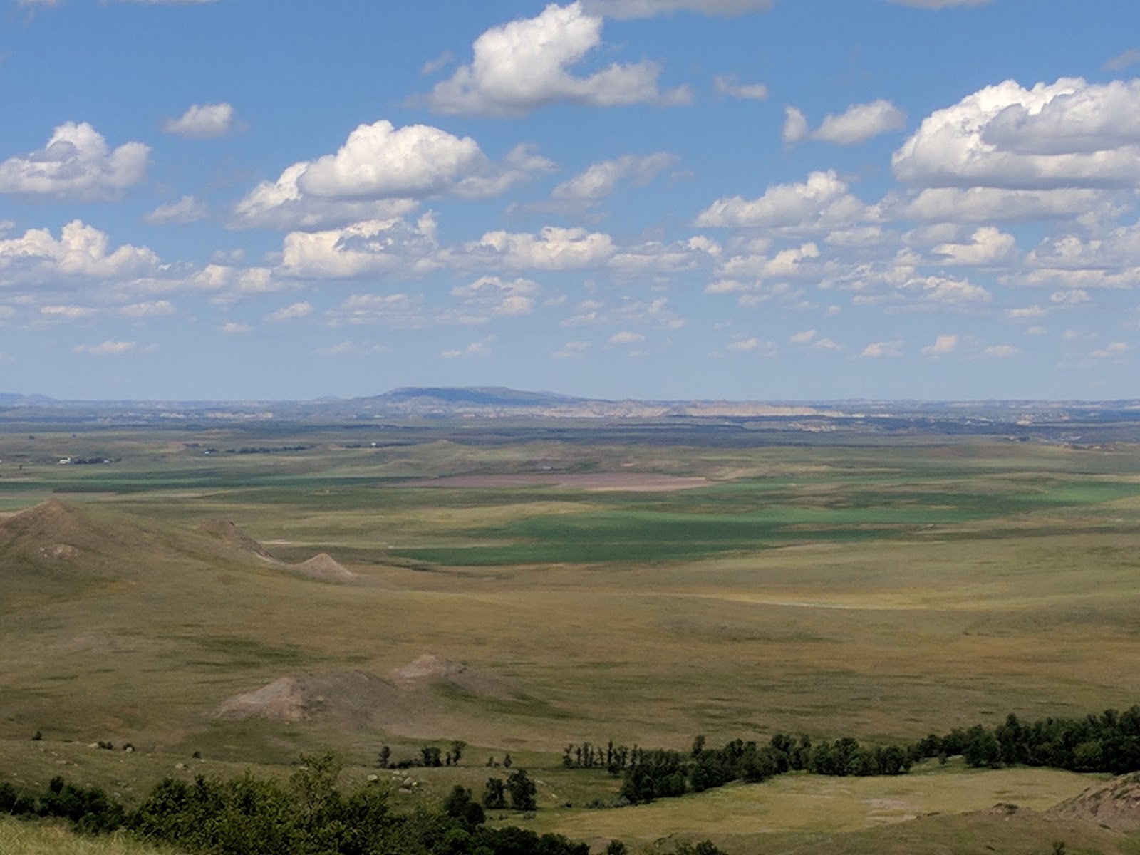
| Looking in the direction of Cash and Deep Creek townships. Our farm was located just west of the hills shown on the horizon |
 |
| A relic from the past |

 |
| Beckie assists us in traversing a barbed wire fence |
 |
| Prickly juniper is almost overwhelming this rock formation. |
 |
| The eagle pits we had read about. More on those later. |

 |
| Remnants of a cow |
 |
| Getting close to the summit |
 |
| Our daughter, Chelsea, happy to have made it to the top |

From The Chadron, Bruele, and Arikaree Formation in North Dakota: the Buttes of Southwestern North Dakota by Murphy, Hoganson, and Forsman (NDGS, 1993):
Black Butte (originally named HT Butte) is a relatively large mesa located 2.5 miles west of the Chalky Buttes...The butte was originally named for the HT Ranch, a prominent horse ranch established in 1884 by the Little Missouri Horse Company. The HT ranch stretched from this butte north to the Little Missouri River. The name Black Butte was likely derived from the dark color of this butte when compared to the white colored rocks at nearby Chalky Buttes....This butte rises approximately 550 feet above the surrounding countryside and was for many years incorrectly identified as the highest point in North Dakota. The top of Black Butte covers an area of approximately 400 acres.

 |
| Looking northwest toward Bullion and the Teepee Buttes |


Our party nearly circumnavigated the perimeter, enjoying the views in all direction, and poking over the edge for closer looks at rock formations, ash draws, and the Sand Creek drainage. I told the party the story of Theodore Roosevelt riding to Mrs. Maddox's ranch on Sand Creek to have her sew the fringed buckskin shirt in which he was later photographed.

Another book from which I read to the party is Bertha Rachael Palmer's Beauty Spots of North Dakota (1928), Chapter XIII.
Standing a short mile distant from one of our main traveled highways is Black Butte sometimes called "H" (H.T.) Butte from the large Horse Ranch of which it was formerly a part. A day or more spent visiting this Butte or small mountain will put you in possession of unforgetable [sic] memories.
Outside of the Bad Lands [note that Palmer also uses "Bad Lands", not "Badlands"] valley on the surrounding prairie, there occasionally rears a small, mountain locally called a Butte, though of a different character than the Buttes of the Bad Lands. Such is Black Butte about eighteen miles north of Bowman and a mile west of the Black and White Trail and the Yellowstone Trail with Dickinson at either main trail.
This Butte is the highest point in the State [sic]. When officially measured it is 58 feet higher than Sentinel Butte [Later, it was determined that White Butte is the highest point in the state. I've hiked that one too.] on the Yellowstone Trail.
The distance around the base is about eight miles, and two miles over the long way of the summit with a varying width of a mile. From the top one can see the "end o' the world" in every direction except east where Chalky Buttes sometimes called White Buttes lie a few miles distant and are a wonderful sight in their great contrast throughout their six or seven miles of white serrated ridge and nakedness. Looking to the southwest one beholds "Round-Top," about six miles distant south are "Twin Buttes" with the little town of Bowman at their feet, northeast about thirty-five miles distant are the "Rainy Buttes" with New England close their feet and northwest approximately forty-five miles "Sentinel Butte" can be seen, while straight north is a beautiful distant view of the Bad Lands.
At the north corner of the top of this grass covered Butte is a hole about three feet long and at a depth of two feet it narrows to a width of six inches. Through this aperture is a slight draft of air. We have dropped pebbles down it and can hear them strike several times but not as if they had found bottom unless it were of mud. It would be interesting to try to measure the depth of this hole. At the western edge of the top which is the highest part, are a couple of pits four feet across and three deep, rock lined. We call them "Eagle Pits" from the fact that they were made by the Indians and used for the purpose of catching the spotted Eagle or "War Eagle" as they were to the Indians who used the wing and tail quills in their warbonnets. The Indians often traded a pony for one of the quills. The procedure of catching the eagles consisted of a "Brave" hiding in one of the pits which would be covered with brush and baited above with raw meat to attract the eagles and when one alighted to feast on the meat the Indian must catch him, it being required that the eagle must be caught alive. It must be remembered too that the Indian was not armed with shooting irons in the early days....
She goes on to describe the eagle pits I mentioned earlier:
Not far from the "Eagle Pits" were several small mounds of stones, in fact there were many such along the edge of the top. None of these mounds were at all prominent being only two or three feet over and about eighteen inches high. We have dug open many of them on this as well as on other buttes and never found anything in them except in a few at the southwest corner of Black Butte and in those we found some small pieces of scarlet flannel that had about a tablespoon of some substance resembling tobacco which was pinched up in the center of the flannel and tied there. In the wrapping was included a loop of grass with the loop wound around with colored grass. We surmised that these were "Medicine bags" of the Indians who had died from some bad reason not understood by the Indians.....
On the south side of the butte is what is called Snow Cave where the winter snows often lie till August. Always the last place where snow is in public view is just at the base of the cap-rock where there is ample opportunity for the winter gales to pile the snow in such vast depths that it takes much summer sunshine and rain to melt it all. The lower half of these great outstanding buttes contain much "black sunshine" in the form of lignite coal, our forest of the bygone ages.
At this point Beckie and I shared with the party that our Aunt Junette Henke, who lives in Bismarck, remembers going as a child to the ice caves and told us that in later years the landowners dynamited the openings in concern for bypassers' safety. Junette also told us that she remembers her father, Andy Silbernagel, telling of going up there to view a "volcanic type" eruption. This is an intriguing story that will require additional research.
Returning to Palmer,
On the north side is a place that may prove of interest to those studying the ancient extinct tribes. It is not at all prominent and most any one would be excused in passing it without notice, but to the observing eye it is distinctly visible. A more or less irregular square or space marked by a ridge of rock. It is about fifty paces across each way and was certainly of man's building, but how long ago? The location goes to show that it was not meant for fortification. As all through this western North Dakota there are circles of stone and mounds so ancient that our Indians have no lore touching them though calling them "Dirt Lodges," we must think that this stone wall belongs to the more ancient tribes. Around both Mandan and Mobridge are the best known mounds.
Scattered about the base of the Butte may be found other pits unlined by stone that were used by the Indians to smoke the skins they were tanning. Black Butte was a favorite camping ground for them with plenty of easily gotten fir wood from its bush draws, and the great springs of fine water, its high level top clothes in heavy grass made ideal pasture for their ponies above the level where flies and mosquitos [sic] were troublesome. Always the distant vision enabled them to sigh friend, foe or game long in advance of their near approach.
Needless to say the rock brush covered sides have always been a friendly haven to the coyotes and in the past to their larger cousins, the gray wolf. Of course, buttes like these were used as look-outs by the cow-boys as well as by the Indians that they supplanted and also by our "dogs of prey." They would lie high up on the sides throughout the day and no one could approach without being seen, and then the coyotes would simply fade away among the gray rock masses. Visitors to Black Butte very often sight them as they are bold in the security of their environment.
We continued our wandering around the top of this marvelous butte, talking of the people of Slope Center and Chalky Butte townships and of our well-remembered ancestors, Emma and Bertha and Clara Hovick (Cash Township), whose lives had been chronicled in The Slope Saga, co-authored by our Aunt Junette. I know it is from these ancestors that we learned the value of thrift and hard work.
 |
| Emma and Bertha Hovick, mining coal on Black Butte in the early 1900s, from The Slope Saga |
I brought this history along with us not only so we can remember their stories, but also so I can share these stories with our children's generation. Alas, Chelsea was the only one of that generation who shared our day on this occasion. We urged her to remember what life was like for these pioneer women, living in these remote places in sod houses.
Here, from the pages of The Slope Saga, is an interesting story about the Black Butte country school, about the visit of an Indian to the schoolchildren:


My husband, the US Navy trained photographer, took pictures of us in the t-shirts he'd bought for us at the Joe Ferris store in Medora.
 |
| The Crook sisters, Beckie Walby, Lillian Crook, Sarah McLaughlin (photo by Jim Fuglie). Indeed, Well behaved women seldom make history |
 |
| Chelsea joins in proudly wearing her Mandan Ohm's Cafe t-shirt (photo by Jim Fuglie) |


 |
| Here is a rare photo: There are few photos of Bullion Butte, in the distance, taken from the top of Black Butte |

 |
| A "puffball" fungi |
 |
| The rare (to western North Dakota) river birch on the more heavily wooded north side |
 |
| It is a long way down here |


 |
| The wild Prairie Rose, in an usual white form (we think due to the soil composition) which is as fragrant as ever |


 |
| I dub this the "Richard Nixon rock" |
 |
| Relics of a bygone day |


 |
| Round-Top Butte, near the farthest north point in our school bus ride of olden days |

We drove north again, guided by our intimate knowledge of this landscape and its roads, with one quick consultation of the Little Missouri National Grasslands map when we took a wrong turn, returning to Medora via the East River Road, sharing with Chelsea our stories about Slope County. Between Bowman and Medora, I counted a grand total of four other vehicles.


 |
| The Teepee Buttes near the Logging Camp Ranch |
Thanks for this article! Brought back some great, and scary, memories. It was probably 30 years ago that we were out in Slope County hunting and Doug Pope, the land owner, drove my husband and I up to the top of Black Butte. It was by far the most harrowing ride of our lives but so worth it to see the view, eagle pits and most intriguing to me the spot where you can drop a rock and not hear it land. I still remember the cold breeze coming out of that hole on a hot fall day and seeing little piles of snow up there.
ReplyDelete